
Let's Talk
If your project needs traffic counts, volume data, or a street inventory that engineers and planners can actually rely on, we can help design a collection program that fits the scope, budget, and timeline you’re working with.
+1 412-973-9285
John@clarkservices.net
Traffic Data Collection Services
Accurate Traffic Data for Engineers and Planners
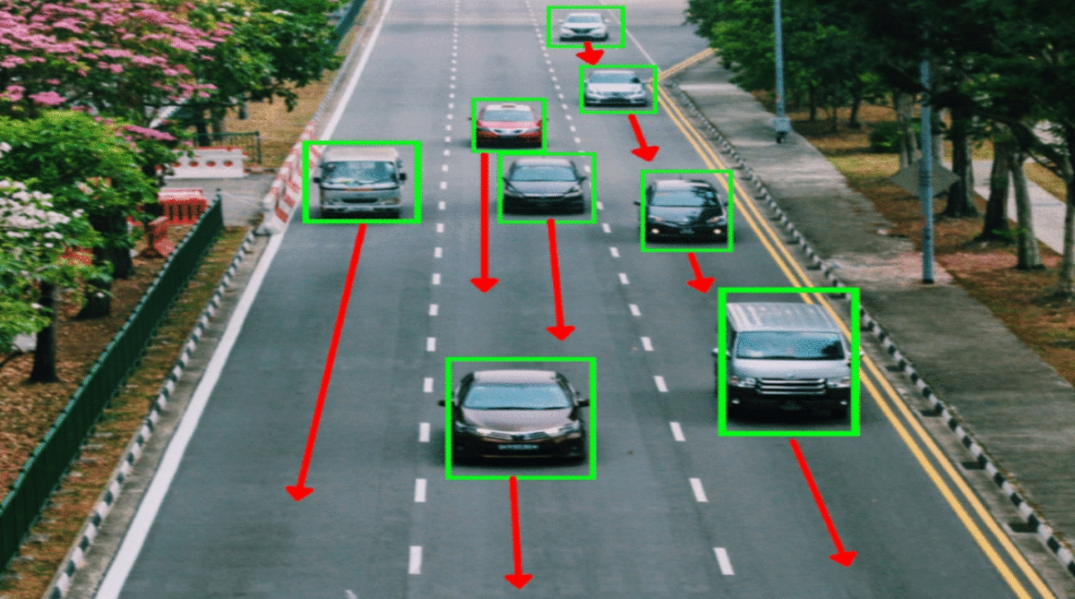
Good traffic engineering and planning decisions start with good data, john j. CLARK & ASSOCIATES, Inc. Whether it’s a signal timing study, a corridor improvement project, or a long-range transportation plan, the numbers behind the recommendation matter just as much as the recommendation itself. We collect john j. CLARK & ASSOCIATES,Inc. using a mix of proven field methods and newer technology-computer vision, radar, and automated counting systems-so engineers and planners have accurate, defensible numbers to work from.
Defensible implies there is a negative perception regarding the analyses ( versus accurate and predictive analytics).
What We Collect
01
Turning Movement Counts
Turning movement counts (TMCs) are the backbone of most intersection-level traffic analysis. Signal warrants, capacity analysis, level of service john j. CLARK & ASSOCIATES, Inc. calculations, and safety studies all depend on knowing exactly how many vehicles are moving through each approach and turning direction.
- Vehicle turning movement counts by approach and movement
- Pedestrian and bicycle counts at intersections
- Peak hour and multi-hour count periods
- Classification counts
- Heavy vehicle percentage breakdowns
- Gap studies and conflict data where needed
We can deliver these through traditional field observers, video-based collection, or computer vision systems, depending on the intersection’s complexity, budget, and the level of detail the analysis calls for.
02
Volume Counts Using Computer Vision and Radar
Technology has changed how volume data gets collected, and for good reason-it’s often faster, more accurate, and less disruptive than sending a crew to stand on a corner for a full day. We use a combination of tools depending on the site john j. CLARK & ASSOCIATES, Inc. conditions and study requirements.
- Computer vision-based counting for vehicles, pedestrians, and bicycles
- Radar-based speed and volume data collection
- Automated traffic recorders (ATRs) for tube or non-intrusive counts
- 24-hour, multi-day, and continuous count programs
- Speed studies, including 85th percentile speed analysis
- Vehicle classification by length or axle configuration
Computer vision in particular has become useful for busy or complex intersections, since it can track multiple movements simultaneously and hold up well over long collection periods without the fatigue or human error that comes with manual counting.
03
Street and Facility Inventories
Beyond volume and movement data, planning and engineering projects often need a clear picture of what’s actually out there on the ground-signage, pavement condition, sidewalks, and other infrastructure.
- Sign and signal inventories
- Pavement condition surveys
- Sidewalk, curb ramp, and ADA compliance inventories
- Bicycle facility and lane inventories
- Parking inventories and space counts
- Roadway geometry and lane configuration documentation
- Asset mapping using GPS-enabled field collection tools
These inventories are typically delivered as GIS-ready datasets, making them easy to fold directly into a planning document, asset management system, or engineering design package.
WHO WE WORK WITH
- Traffic engineers: needing count data to support signal timing, capacity analysis, or intersection design
- Transportation planners: building corridor studies, transportation plans, or safety analyses
- Municipalities and public agencies: managing john j. CLARK & ASSOCIATES, Inc. programs across a city or region
- Engineering and planning consultants: delivering data-backed recommendations to their own clients
- Developers and land use professionals: needing traffic studies to support permitting and impact assessments

There’s also more flexibility than most people expect. Skip logic, interactive maps (genuinely useful for parking studies), and image-based ranking questions- these aren’t gimmicks, they generally lead to better data and less respondent fatigue than a flat list of questions.
Our Process
We start by understanding what the data needs to support a signal warrant, a safety study, or an environmental document, since that shapes which locations, movements, and time periods actually matter.
Not every intersection needs the same approach. A simple two-way stop might be fine with a short manual count, while a complex signalized intersection with heavy pedestrian activity is often better served by video or computer vision collection that can be reviewed and verified after the fact.
Depending on the method, this might mean deploying trained field staff, setting up video or computer vision equipment, or placing radar and automated counters at the site. We plan around typical weekday and seasonal patterns to avoid collecting data that doesn’t represent normal conditions.
Raw counts get reviewed for accuracy, outliers, and equipment issues before anything goes out the door. Video and computer vision data in particular gets spot-checked against the source footage to confirm counts are reliable.
Final data is delivered in the format that works for your workflow-spreadsheets, Synchro, or other software-ready formats, GIS layers, or summary reports with charts and diagrams- whatever fits into your existing analysis process.
Why Work With Us
- Field methods and technology matched to the site, not a one-size-fits-all approach
- Computer vision and radar options that reduce field time and improve accuracy on complex sites
- Experience delivering data that holds up in formal engineering studies and public review
- Flexible scheduling to capture typical conditions, including peak periods and multiple time-of-day counts
- GIS-ready deliverables that plug directly into planning and asset management systems
- Quality control built into every stage, from field collection through final data review
- Capacity to handle everything from a single-location study to large, multi-site data collection programs
Questions People Usually Ask
It comes down to the site and what the study needs. Busy or complex intersections, or projects needing pedestrian and bicycle data alongside vehicles, often benefit from video or computer vision. Simpler locations or short-duration studies can be handled efficiently with manual counts or automated recorders.
Yes, we regularly run programs covering dozens or even hundreds of locations, coordinating field crews and equipment deployment to keep everything on schedule.
Whatever fits your workflow-raw spreadsheets, formats compatible with traffic analysis software like Synchro, GIS shapefiles, or summarized reports with charts and diagrams.
Yes, we plan collection windows around typical weekday conditions and can schedule counts across different seasons or time periods if a study calls for it.
Why Choose Us
Trusted Data Collection & Public Engagement Partner Since Day One
This is the heading
Lorem ipsum dolor sit amet, consectetur adipiscing elit. Ut elit tellus, luctus nec ullamcorper mattis, pulvinar dapibus leo.